Project Description
Detailed representations of riverine flooding prepares coastal urban areas for inundation hazards. This project focuses on hydraulic modeling of extreme flood events including precipitation and water surface elevations in New Haven and Fairfield counties. The sensitivity of wetlands to a combination of fluvial, tidal, and coastal sources of flooding will be assessed, accounting the different rates of sea level rise. The project aims to demonstrate the exacerbated effect of river flows with rainfall and sea level rise estimation in different climate change scenarios.
Project Timeline: June 2020 - June 2021
Project Outcomes
The following tasks and outcomes of the project include:
- Identify historic rain and storm surge events and evaluate the extent of tide in these different events.
- Identify the likelihood of flooding due to just precipitation caused by riverine flooding in different watershed scales. This task will guide the regions where they need to worry about the surge and where they need to worry about the only precipitation caused flooding.
- Report the watershed capacity and river volume flux for selected regions.
- Identify the flood risk by changing land use in different watersheds.
- Identify the systems where the river flooding changes drastically with the existence of flow control structures.
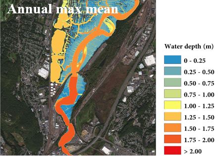
A technical report and GIS maps will be posted to this site when they become available.
UConn Today Feature Article:
Don’t Get Soaked: Flood Damage Could Lessen if Cities Build Smarter
Project Fact Sheet
Webinar
Original air date June 14, 2021 – View slides and a recording HERE
Researcher
Xinyi Shen, Asst. Research Professor, UConn Department of Civil and Environmental Engineering
Kang He, PhD. Student, UConn Department of Civil and Environmental Engineering