Areas that are more vulnerable to climate change are ones where people, infrastructure, and/or ecological resources are more likely to experience harm as temperatures rise, floods worsen, and high winds increase. Vulnerability is a complex concept and encompasses a variety of elements including physical exposure, sensitivity or susceptibility to harm, and lack of capacity to cope and adapt. Understanding vulnerability helps us to make decisions about resource allocation, policy development, and project prioritization, siting, and design. View a Climate Change Vulnerability Index (CCVI) Fact Sheet and the following tools to better understand climate vulnerability across the state of CT. The spanish version of the factsheet can be found under "Additional Climate Vulnerability Information" below.
Climate Change Vulnerability Index (CCVI) Viewers
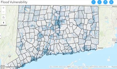
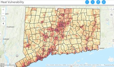
The CCVI combines built, social, and ecological factors to identify areas that are vulnerable to flooding and heat related impacts of climate change. These mapping tools can be used to view vulnerability at both a regional scale and at specific sites to see how factors are contributing.
The CCVI Viewer Story Maps below help guide users through each viewer's content and how to navigate and print maps. You can also view the CCVI Factsheet that will prove additional information on the data that went into creating the CCVI.
Additional Climate Vulnerability Information:
Resilient Connecticut Story Map
Índice de Vulnerabilidad del Cambio Climático (IVCC)
2023 CCVI Webinar Video -Sustainable CT: Planning for Extreme Heat - How to Use CIRCA's Climate Change Vulnerability Index
CCVI Overview Presentation Slides
CCVI Applications Presentation Slides
CCVI Zoning Application Presentation Slides
Winter, 2021 Workshop: The Resilient Connecticut team held their first regional workshops with four Council of Governments (COGs) in New Haven and Fairfield Counties. Workshops included two information sessions to learn about Climate Change Vulnerability Index (CCVI) and Zones of Shared Risk (ZSR) findings. Each session was followed by small group collaboration exercises to discuss, refine, and to better understand these tools for future resilience planning efforts.
Spring, 2021 Workshop: At the second set of workshops, areas at-risk from flooding and heat were highlighted and group conversations focused on areas that present “resilience opportunities” in New Haven and Fairfield Counties. These areas are not just places at risk from high heat or high flooding. They are also areas with high social vulnerabilities, regional assets like wastewater treatment plants, water supplies, energy facilities that serve multiple communities, and may have the potential to support more resilient transit and housing. Gaining local knowledge and expertise through engagement like these workshops are important to wrap up Phase II of the project.
Connecticut Climate Fact Sheets and Full Reports: A state focused temperature and precipitation fact sheet summarizes climate projections in the full report, Connecticut Physical Climate Science Assessment Report. A second sea level rise fact sheet summarizes results from CIRCA’s 2019 Sea Level Rise in Connecticut Final Report and includes flood frequency and storm surge information.