Project Description
Due to climate change, heat waves are expected to become more frequent and severe, which can be dangerous to human health and wellbeing. Individuals who are not as acclimated to heat, like Connecticut residents are potentially at high risk for heat related illnesses during periods of extreme heat. Those who live in urban areas experience warmer air temperatures than those who live in rural areas, due to the Urban Heat Island Effect. Products of urbanization like asphalt, high concentration of buildings, and lack of vegetation cause urban areas to retain more heat. This project aims to identify the variability of air and surface temperature overtime and its linkages to urbanization, focused in Danbury, Connecticut. Heat Index data will be collected through the deployment of 12 wireless heat sensors mounted on electric poles or trees, throughout the city of Danbury.
Project Timeline: June 2022 – October 2022
Project Goals
The main objective of this project will be to map and identify vulnerable areas to heat, extreme climate conditions, and identify the contribution of the changes in heat to vulnerability. The data will be used to model the differences between heat sensor and satellite measured temperatures and heat vulnerability in the area.
- Danbury Is Heating Up: Here’s What the City is Doing to Prepare and Help Residents Cope
The Data
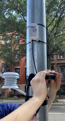
The sensors record temperature, relative humidity, and dew point temperature at street level, approximately 8-10 ft above ground.
Equipment
The HOBO MX2300 series data loggers record and transmit temperature and/or relative humidity (RH) in outdoor or indoor environments. These Bluetooth Low Energy-enabled loggers are designed for wireless communication with a mobile device. Using the HOBOconnectTM app, you can easily configure the logger, read it out, and view data on your phone or tablet, or export the data for further analysis. Click HERE for more information about the sensors.
Sensor Locations
-
- Danbury Hospital
- Housing Apartments (Eden Drive)
- Laurel Gardens
- Danbury Housing Authority Apartments (Mill Ride Road)
- Danbury Housing Authority Apartments (High Ridge Road)
- East Ridge Condos
- Glen Apartments
- Danbury Housing Authority Apartments (Fairfield Ridge Road)
- Wooster Manor
- Danbury Commons
- Putnam Towers
- Summit One
- Danbury Towers
Partners
Danbury Emergency Management
Frequently Asked Questions
| Question | Answer |
| How are the sensors going to affect the public? | CIRCA’s research team placed the heat sensors 8-10ft above the ground and will be out of reach, meaning they are of no danger to the public. |
| How are the sensors identified? | Each sensor has a UCONN identification code as well as a QR code that links users to our project page. |
| Did CIRCA receive permission to install the heat sensors? | Yes, CIRCA has partnered with Danbury Emergency Management where they received the necessary permits for each sensor location. |
Do you have any more questions and/or concerns? Contact circa@uconn.edu