Project Description
Connecticut’s coastline is vulnerable to tidal flooding from its rivers and Long Island Sound. In addition, this coastline is characterized by a complex topography with large presence of bays, harbors, coves, as well as wetlands and hills. This complexity affects the spatial distribution of human and physical capital in the region and thus the economic efficiency of any strategies designed to protect them from storm surges.
In this study, the research team conducted cost-benefit analysis of various flood risk reduction plans in New Haven and Fairfield counties. They concentrated specifically on the spatial variability of defense plans and examined how a uniform solution across a large region compared to more local solutions that focus on a specific cove, bay, or wetland.
The team began by drawing different flood plain sizes across the region, then identified the location and length of seawall that will protect each flood plain. They also inspected the height of the roads within the flood plains and selected the roads that could be raised to match the benefits offered by a seawall solution. And in areas where seawall and road-raising are not feasible, they looked at how buildings could be elevated. For the economic analysis, their workflow built upon a method which combines flood modelling and the FEMA’s HAZUS model to estimate storm surge damage in the study area. To estimate the costs, the team looked at existing literature and projects (e.g. road-raising project in West Haven).
Project Timeline: May 2019 - December 2020
Project Outcomes
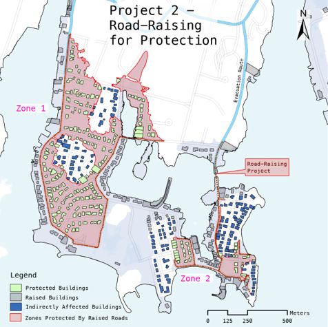
This study identified 5 flood risk reduction projects in Norwalk, a coastal town in the Fairfield county. In total, there are over 1,200 buildings at risk of flooding from a 1/100-year flood (11 feet), with an estimated total value of $578 million USD. In addition, 330 other buildings outside of flood zones will have no evacuation route in case of a 1/100-year flood event.
The cost benefit analysis of the Norwalk’s coastline reveals that there are over eight flood risk reduction projects that are worth implementing – these eight areas will be summarized in a final report and posted on this site when available. Proposed strategies are based mainly on remote spatial analysis and need to be examined on the field to assess their pertinence and to see whether there is already an existing defense structure in place.
Project Team
Andry Rajaoberison, Geospatial Analyst, UConn CIRCA
Robert Mendelsohn, Yale University School of Forestry and Environmental Studies