Statewide Resilience Roadmap Recommendations
 CIRCA and project partners will provide guidelines for the state and municipalities to achieve the following:
- Improve the integration of field research to inform site planning and the translation of data to site scale planning choices;
- Improve the integration of modeling, informed analysis, and interpretation of model results to guide planning and risk based decision-making. Risk = the probability of an event x the vulnerability of an area;
- Strengthen the regional and multi/cross jurisdictional resilience planning approaches including the state's existing programs (e.g. state level programs and COGS);
- Improve the bottom up and top down coordination (state to municipal, municipal to homeowner);
- Explore, test and integrate a balanced approach to practical and innovative planning, design and implementation strategies into existing documents such as the hazard mitigation, CRP and POCD;
- Define and address legal and economic obstacles and permitting challenges;
- Define and address implementation and management issues; and
- Provide capacity building for resilience planning and projects in Connecticut.
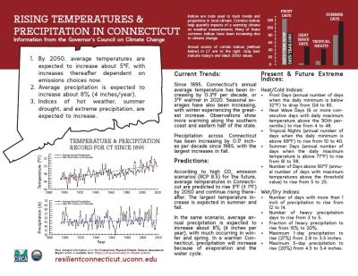
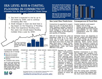
Connecticut Climate Fact Sheets
Planning for adaptation requires local information about expected changes in climate. Until recently, the spatial scale of climate projections did not allow for detailed regional analysis. With support from CT DEEP, CIRCA sponsored two recent state-level climate assessments to better inform local decision-making. If you don't have time to read the full Sea Level Rise Final Report or the Physical Climate Science Assessment Report then these two fact sheets can help you find results quickly:
CIRCA Temperature and Precipitation Fact Sheet
CIRCA Sea Level Rise Fact Sheet
 |
 |