Climate Change Vulnerability Index Webinar: Progress and New Results for Heat and Wind

March 3, 2021

Resilient Connecticut Webinar Series

March 23, 2021
10 – 11:00 am

REGISTRATION

Webinar Overview

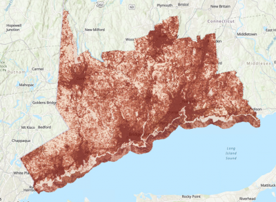
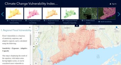
The Resilient Connecticut team will host a webinar on Tuesday, March 23 to highlight new results for the Climate Change Vulnerability Index (CCVI) mapping tool. The webinar will include a brief overview of the latest flood CCVI tool, with a specific focus on revisions made in response to last month’s regional workshops (to view workshop videos and materials, click here). In addition, the team will describe new heat and wind vulnerability findings, review source datasets, and answer questions from webinar participants. This new comprehensive CCVI, with combined flood, heat, and wind stressors, will inform regional resilience opportunities and pilot projects.

Webinar Presenters

Victoria Vetre and David Murphy, Milone & MacBroom

Watch the Webinar Recording

New UConn Course – Climate Crisis: Take Action

March 2, 2021

Climate course students

A new free course on climate change, taught by faculty from across the university, is available to students for one credit and faculty and staff as non-credit. “Climate Crisis: Take Action” is a course that takes a transdisciplinary approach to the exploration of climate change and how we can collectively address this complex issue. This course begins Monday, March 1st for students and Monday, March 8th for faculty and staff and ends on Wednesday, April 28. More detailed course information is on the Provost’s site.

The course is led by many of CIRCA’s affiliated faculty including:

  • Carol Atkinson-Palombo, Director, Environmental Studies Program,  Associate Professor, Dept of Geography
  • Christine Kirchhoff, Assistant Professor, Department of Civil and Environmental Engineering
  • Carolyn A. Lin, Professor, Department of Communication
  • Joseph MacDougald, CIRCA Director of Applied Research, Professor-in-Residence, School of Law
  • Anji Seth, CIRCA Director of Applied Research, Associate Professor, Department of Geography
  • Guiling Wang, Professor, Department of Civil and Environmental Engineering

Read UConn Today Article: Climate Crisis: Take Action’ Is Third Pop-Up Class Offering at UConn

Faculty and staff can enroll in the course on HuskyCT.

All undergraduate and graduate students should enroll at this link

For more information, contact: Provost’s Office at climateaction@uconn.edu

January 2021 Project Update

February 22, 2021

CIRCA Launches the Resilient Connecticut Collaborative
The CIRCA team is excited for the launch of the Resilient Connecticut Collaborative (RCC). There are currently 19 committed members from 16 different regional and state-wide organizations. Members represent conservation, utility, real estate, historic resources, planning, agriculture, food, and environmental justice organizations. The first meeting, held in January, focused on the Climate Change Vulnerability Index and included icebreaker activities, short Resilient Connecticut project presentations, and breakout groups on a mapping tool. We incorporated several digital tools to enhance the virtual meeting experience including Microsoft Teams, Slido, and Miro. The RCC will meet 4-6 times throughout 2021. While an advisory group, the RCC is also a facilitated community of practice where members can share their organization’s goals, network with each other, and advance their understanding of climate change. If you have any questions or would like to learn more, please contact Joanna Wozniak-Brown, Assistant Director of Resilience Planning, joanna.wozniak-brown@uconn.edu

Updated Zones of Shared Risk Maps for Coastal Towns
Zones of shared risk maps are now updated for 14 coastal towns in the Resilient Connecticut region of New Haven and Fairfield Counties. This new update by UConn Professor Peter Miniutti and his research team includes zones of shared risk maps that consider infrastructure, hydrological, ecological, social, and institutional elements of a community. For more information about this project, please visit the Defining Zones of Shared Risk project page and download updated maps and datasets here.

Workshops Held in Four COG Regions
The Resilient Connecticut team held their first regional workshops with four Council of Governments (COGs) in New Haven and Fairfield Counties. Workshops included two information sessions to learn about preliminary Change Vulnerability Index and Zones of Shared Risk findings. Each session was followed by small group exercises to discuss, refine, and to better understand these tools for future resilience planning efforts. The inclusion of regional stakeholder input is an important component of shaping these tools, and ultimately identifying resilience pilot projects throughout the regions. To watch workshop videos, view slides, download fact sheets, or explore preliminary map viewers, please see the workshop website. NOTE: due to inclement weather the final MetroCOG workshop was changed to Monday, February 8.  A second regional workshop series will be held this spring so keep an eye out for the schedule in future Roundup news!

Winter Workshops in Four COG Regions

January 7, 2021


The Resilient Connecticut team held workshops with four Council of Governments (COGs) in New Haven and Fairfield Counties. The workshops reviewed the preliminary Climate Change Vulnerability Index (CCVI) and Zones of Shared Risk (ZSR) findings. Participant input is helping ensure these products reflect climate risks in their communities.

The workshop included two information sessions on the CCVI and ZSR findings. Each session was followed by small group collaboration exercises to discuss, refine, and to better understand these tools for future resilience planning efforts. The inclusion of regional stakeholder input is an important component of shaping these tools, and ultimately identifying resilience pilot projects throughout the region.

To watch workshop videos, view slides, download fact sheets, or explore preliminary map viewers, please see the workshop website for information about the following events:

Naugatuck Valley COG (NVCOG)
January 22, 9:30 – 12:00

Western Connecticut COG (WestCOG)
January 25, 9:30 – 12:00

South Central Regional COG (SCRCOG)
January 29, 9:30 – 12:00

Metropolitan COG (MetroCOG) 
February 8, 9:30 – 12:00


Workshop Flyer Announcement with Spanish translation and registration links


November 20th Resilient Connecticut Virtual Summit a Success!

December 2, 2020

Over 250 people registered for the second Resilient Connecticut Summit that drew a diverse audience from municipalities, state and federal agencies, COGs, consultants, academics and interested public. Remarks from U.S. Senator Chris Murphy highlighted the importance and urgency of enacting climate mitigation and adaptation strategies from municipal to national levels. Professor Barry Hill’s keynote presentation provided thought-provoking insights on the relationship between environmental justice and climate justice and how attorney generals in several different climate change cases are seeking to address these issues. During the Summit participants could choose between one of three breakout sessions to hear from diverse speakers and ask questions on the following topics:
  • Resilience Planning: Challenges, Opportunities and Interconnections
  • Building Technical Capacity and Tools for Municipal Resilience
  • Climate Adaptation Policy and Implementation
See the Summit website for more information, videos from the event, and links to presentations.

November 2020 Project Update

December 1, 2020

Register for the Resilient Connecticut Nov. 20th Summit
While waiting for today’s election results, why not REGISTER for the second Resilient Connecticut Summit to be held on November 20, 2020? This half-day, virtual event is open to the public and free to attend. Participants will learn about CIRCA’s recent Resilient Connecticut project activities, participate in breakouts with partners, and hear from a keynote speaker. View a detailed agenda on the Summit Website and register by November 17 (a link to join the event will be sent to registrants on November 19). This event is eligible for 2.75 hours of CM credit through the Connecticut Chapter of the American Planning Association.
Resilient Connecticut Stakeholder Evaluation Survey Closed Nov. 1st
Dr. Miriah Russo Kelly, Assistant Professor in the Dept. of Environmental, Geography, and Marine Sciences at Southern Connecticut State University, worked with the CIRCA team to develop a stakeholder evaluation survey. The survey was distributed to a variety of organizations that may use or be impacted by the Resilient Connecticut project. The survey was designed to assess their interests, needs, and preferences. The results will inform the products and planning process for the project. If you have any questions about the survey, please email Dr. Miriah Russo Kelly. If you have questions about the Resilient Connecticut project, please email CIRCA’s Dr. Joanna Wozniak-Brown.
New Dataset Models Long Island Sound Extreme Storms
A coastal circulation and wave model (FVCOM-SWAVE) for the highest 44 storms between 1950 and 2018 is available for Long Island Sound. The hourly outputs of water level and wave height from 44 simulations in NetCDF format are provided (NetCDF data covers Long Island Sound, Block Island Sound, and the adjacent shelf south of Long Island). The duration for each storm simulation is between 5 to 8 days. As described in a recent journal article the North Atlantic Coast Comprehensive Study (NACCS) mean results “are higher for water levels and lower for significant wave heights for longer return periods” compared to CIRCA’s model. Comparison with the FEMA results also show differences in eastern and western LIS. In addition to evaluating historic risks, CIRCA also added a sea-level height offset of 20 inches for 2050 estimates in order to examine the effect of rising sea-levels on the analysis. “We find that sea-level rise reduces the return period of a ten year storm to two years.” To help decision-makers better understand extreme storms, CIRCA now has products available from this study (please email CIRCA’s Dr. Yaprak Onatwith questions):

Dataset of storm surge and significant wave heights for CT coastal towns.

Viewer for projected storm surge water levels and significant wave heights.

YouTube video explaining this new journal article’s methodology and results.


Connecticut Climate Fact Sheets Now Available

October 7, 2020

Planning for adaptation requires local information about expected changes in climate. Until recently, the spatial scale of climate projections did not allow for detailed regional analysis. With support from CT DEEP, CIRCA sponsored two recent state-level climate assessments to better inform local decision-making and are a new addition to the Institute’s climate planning tools. Don’t have time to read the full reports or want to have information in a one-page fact sheet for handouts?  These two products can help you find results quickly: 

CIRCA Temperature and Precipitation fact sheet

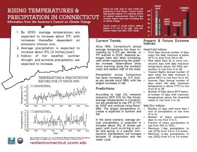
In 2019 a team of UConn researchers reviewed the current state of knowledge of the physical science for observed and projected climate trends and extremes in Connecticut. The result is a report, Connecticut Physical Climate Science Assessment Report that provides a state-level assessment for temperature and precipitation. Study results highlighted in this fact sheet include:

  1. By 2050, average temperatures are expected to increase about 5 degrees, with increases thereafter dependent on emissions choices now.
  2. Average precipitation is expected to increase about 8% or 4 inches/year.
  3. Indices of hot weather, summer drought, and extreme precipitation, are expected to increase.

CIRCA Sea Level Rise Fact Sheet

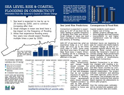
A second fact sheet expands on CIRCA’s 2019 Sea Level Rise in Connecticut Final Report with flood frequency and storm surge information. Those in touch with Connecticut’s climate news have likely heard CIRCA’s recommendation that Connecticut plan for up to 20 inches (50cm) of sea level rise by 2050 and that levels will likely continue to rise after that date without further mitigation. These study results along with with new text and figures are highlighted including: 

  1. Small changes in mean sea level have a big impact on the frequency of flooding.
  2. Areas that experience flooding every few years now should expect flooding multiple times a year by 2050.

CIRCA is working with the Governor’s Council on Climate Change (also known as the GC3) and through our membership on the Science and Technology Working Group to include the latest science from these two studies into state climate policy decisions.  Originally established in 2015, Governor Ned Lamont issued Executive Order No. 3 on September 3, 2019 to re-establish and expand the GC3 membership and responsibilities.  More information on the GC3 and its recent series of public forums can be found here.

Resilient Connecticut Summit – November 2020

September 16, 2020

Friday, November 20, 2020
9:00 – 11:45 am

CIRCA hosted the second annual Resilient Connecticut Summit on November 20, 2020 as a half-day, virtual event that was open to the public and free to attend. Participants learned about recent project activities, participated in breakouts, and heard from keynote speaker Barry E. Hill, a visiting Scholar at the Environmental Law Institute, which is a Washington, D.C. based environmental law and policy think tank and adjunct Professor at the Vermont Law School.  Professor Hill presented on the topic of Attorney Generals “Addressing Instances of Environmental/Climate Injustice Through Climate Change Litigation”. This presentation is timely as the Connecticut Office of the Attorney General filed a complaint against ExxonMobil in September.  Participants also chose between three breakout sessions focused on resilience planning, building technical capacity and tools for resilience, and climate adaptation policy and implementation.

See the Summit website for program materials.

September 2020 Project Updates

September 11, 2020

Zones of Shared Risk Map Dataset.

“Zones of Shared Risk” are regions that face common challenges currently or expected as a result of climate change. These risks are shared among or between groups of people that may have different perspectives and priorities for coastal resilience. UConn Plant Science and Landscape Architecture Department’s Professor Peter Miniutti and his team prepared Zones of Shared Risk maps for the 14 towns in the Resilient Connecticut region. The maps include built infrastructure, hydrological, ecological, social, and institutional elements that contribute to the functioning of a place. Explore the dataset at our website
 

Identifying Heat Vulnerability and Land-use Influence

CIRCA partner and UConn Plant Science and Landscape Architecture department’s Assistant Professor Mariana Fragomeni and her team are advancing climate change research. The objective of their study will be to map and identify areas vulnerable to heat and cold, areas of extreme climate conditions, and the contribution of the changes in heat to vulnerability. For this purpose, CIRCA deployed 20 temperature and humidity sensors in various landscape and demographic typologies in the city of New Haven. CIRCA would like to thank the City of New Haven for their collaboration and help in selecting the locations for the sensors. The information on this project will be updated at our website.

August 2020 Project Updates

August 24, 2020

The ongoing health crisis has been a challenge for us all. While most of CIRCA’s work, transitioned to virtual formats this past spring, the hard work and efforts of everyone at UConn, CIRCA, and our partners allowed us to keep the Resilient Connecticut project on track, and we thank everyone for their efforts during this difficult time. Phase II of Resilient Connecticut is underway, led by a planning team of Milone & MacBroom, Dewberry, West COG, Metro COG, Naugatuck Valley COG, South Central Regional COG, and the CIRCA research team.

The major tasks in Phase II include inventorying and mapping previous hazard mitigation and resilience projects and data, developing a comprehensive vulnerability assessment of regional climate challenges in Fairfield and New Haven Counties, and developing adaptation scenarios that address these challenges that are implementable.

Input and engagement with a broad range of stakeholders is a fundamental ingredient needed for developing a long term vision for how the region can adapt to climate challenges. For at least the remainder of 2020, in person engagement activities will be limited. However, we’ll be moving to virtual engagement, starting with a “mini” webinar series focused on climate and public health (described below). Other engagement activities will include regional virtual workshops in the project area. And, of course, be sure to save the date annual Resilient Connecticut Climate Adaptation Summit on Friday November 20th. Look for more details on the agenda and registration links very soon.

Advancing Connecticut’s Climate GIS Capacities

Decisions need data and good decisions need good data. In addition to our Sea Level Rise viewer and Coastal Vulnerability Index, we have been working with a number of partners to advance the GIS science for resiliency decision making in Connecticut.

CIRCA has been meeting with COG GIS staff in the Resilient Connecticut project area to coordinate layers that are critical to understanding regional vulnerabilities and, eventually, resiliency opportunities. COGs conduct economic development, transportation, and environmental planning across their towns and produce important GIS layers to communicate information and to identify key intersections of the underlying topics. Each meeting we discuss existing data, creating data from regional planning processes, and aligning attributes and symbology in the data for consistency across the regions. The data will be further developed into the data and plans created by our consultants.

In addition, CIRCA has participated in several meetings about the production of an Environmental Justice mapping tool for the state of Connecticut. This tool is one of the draft suite of actions established by the Equity and Environmental Justice working group of the Governor’s Council on Climate Change. The proposed tool would integrate environmental, social, and economic GIS layers to identify vulnerable populations.

To learn more, please contact our Assistant Director of Research, Dr. Yaprak Onat at yaprak.onat@uconn.edu.

Climate Change & Public Health: Mini-Webinar Series

As we are vividly seeing with the coronavirus pandemic, public health is a foundational piece of a resilient community. Throughout the month of September, hear about Climate Change and Public Health in our mini-webinar series. Focused on topic and condensed on time, enjoy 1,2, or all 6 of our free webinars!

Each webinar will be 45 minutes with about 30 minutes of presentation and 10-15 minutes for questions or interactive exercises. Hear from our incredible line-up of speakers from partners across the region, including Save the Sound, Cary Institute for Ecosystem Studies, Yale Center on Climate Change and Health, the Connecticut Department of Public Health, Save the Sound, the city of Norwalk, and, of course, UConn researchers.

Registration will open soon. More information may be found here.